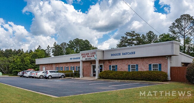
Property Record
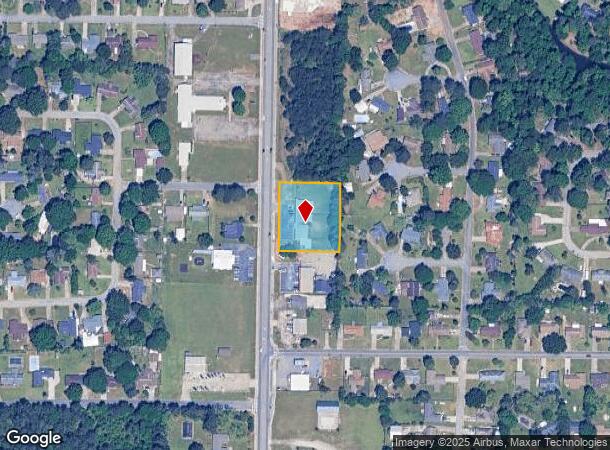
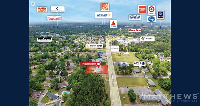
1012 Carl Vinson Pkwy, Warner Robins, GA 31093
NEARBY LISTINGS FOR SALE OR LEASE
Property Detail
1012 Carl Vinson Pkwy
Warner Robins, GA
Carl Vinson 300 Ff
0W0720178000
PARCEL 3-B 1.036 ACRES 150/5TH
Kennel
Houston
X
Georgia
13021C0245G
150
2024
1.01 AC
2024
Perry/Warner Robins
020111
Other Market Areas
4,477 SF
DEMOGRAPHICS near 1012 Carl Vinson Pkwy
1 Mile
3 Mile
5 Mile
2024 Total Population
6,734
47,727
92,154
2029 Population
7,307
52,325
100,717
Pop Growth 2024-2029
+ 8.51%
+ 9.63%
+ 9.29%
Average Age
40
38
38
2024 Total Households
2,668
19,305
36,791
HH Growth 2024-2029
+ 8.28%
+ 9.42%
+ 9.15%
Median Household Inc
$58,111
$53,114
$58,320
Avg Household Size
2.50
2.40
2.40
2024 Avg HH Vehicles
2.00
2.00
2.00
Median Home Value
$123,120
$128,531
$140,025
Median Year Built
1978
1978
1985
Nearby Places
Map Layers
Map Styles
 Street
 Aerial
- Restaurants
- Banks
- Shops
- Fitness
- Groceries
SALE & LEASE HISTORY
LISTING DATE
SALE/LEASE

May 12, 2022
For Sale
Nearby Properties
Address
Land Use
TOTAL SIZE
Lot Size
Zoning
Address
Land Use
TOTAL SIZE
Lot Size
Zoning
780,000 SF
70.50 AC
M-2
Address
Land Use
TOTAL SIZE
Lot Size
Zoning
11,658 SF
30.23 AC
R2
Address
Land Use
TOTAL SIZE
Lot Size
Zoning
14,754 SF
24 AC
C2
Address
Land Use
TOTAL SIZE
Lot Size
Zoning
226,032 SF
49.90 AC
C2
Address
Land Use
TOTAL SIZE
Lot Size
Zoning
11,056 SF
17.41 AC
R4
Address
Land Use
TOTAL SIZE
Lot Size
Zoning
301,206 SF
19.79 AC
C2
Address
Land Use
TOTAL SIZE
Lot Size
Zoning
304,246 SF
23.11 AC
C2
Address
Land Use
TOTAL SIZE
Lot Size
Zoning
92,930 SF
18.66 AC
C2
Address
Land Use
TOTAL SIZE
Lot Size
Zoning
158,300 SF
29.99 AC
R1
Address
Land Use
TOTAL SIZE
Lot Size
Zoning
21,750 SF
11.48 AC
C2
Address
Land Use
TOTAL SIZE
Lot Size
Zoning
223,608 SF
22.40 AC
C2
Address
Land Use
TOTAL SIZE
Lot Size
Zoning
11,200 SF
7.60 AC
R4
Address
Land Use
TOTAL SIZE
Lot Size
Zoning
15,184 SF
14.03 AC
R4
Address
Land Use
TOTAL SIZE
Lot Size
Zoning
6,336 SF
27.16 AC
R4
Address
Land Use
TOTAL SIZE
Lot Size
Zoning
128,540 SF
32.26 AC
R2
Address
Land Use
TOTAL SIZE
Lot Size
Zoning
139,016 SF
24.71 AC
C2
Address
Land Use
TOTAL SIZE
Lot Size
Zoning
100,000 SF
19.66 AC
R1
Address
Land Use
TOTAL SIZE
Lot Size
Zoning
132,851 SF
24.05 AC
C2
Address
Land Use
TOTAL SIZE
Lot Size
Zoning
125,797 SF
5.74 AC
M2
Address
Land Use
TOTAL SIZE
Lot Size
Zoning
90,000 SF
12 AC
R1
Address
Land Use
TOTAL SIZE
Lot Size
Zoning
125,412 SF
9.82 AC
C2
Address
Land Use
TOTAL SIZE
Lot Size
Zoning
61,628 SF
45 AC
C2
Address
Land Use
TOTAL SIZE
Lot Size
Zoning
121,500 SF
10 AC
R2
Address
Land Use
TOTAL SIZE
Lot Size
Zoning
84,909 SF
8.64 AC
C2
Address
Land Use
TOTAL SIZE
Lot Size
Zoning
16,576 SF
13.47 AC
R4
Address
Land Use
TOTAL SIZE
Lot Size
Zoning
31,797 SF
9.45 AC
R2
Address
Land Use
TOTAL SIZE
Lot Size
Zoning
5,400 SF
16.21 AC
R4
Address
Land Use
TOTAL SIZE
Lot Size
Zoning
108,500 SF
10.85 AC
C2
Address
Land Use
TOTAL SIZE
Lot Size
Zoning
8,752 SF
11.71 AC
R4
Address
Land Use
TOTAL SIZE
Lot Size
Zoning
4,720 SF
12.53 AC
C2
The World's #1 Commercial Real Estate Marketplace
Connect with us
© 2025 CoStar Group
The information above has been obtained from sources believed reliable. While we do not doubt its accuracy we have not verified it and make no guarantee, warranty or representation about it. It is your responsibility to independently confirm its accuracy and completeness. Any projections, opinions, assumptions, or estimates used are for example only and do not represent the current or future performance of the property. The value of this transaction to you depends on tax and other factors which should be evaluated by your tax, financial, and legal advisors. You and your advisors should conduct a careful, independent investigation of the property to determine to your satisfaction the suitability of the property for your needs.